Geography Class 33

Walker circulation (5:39 PM)
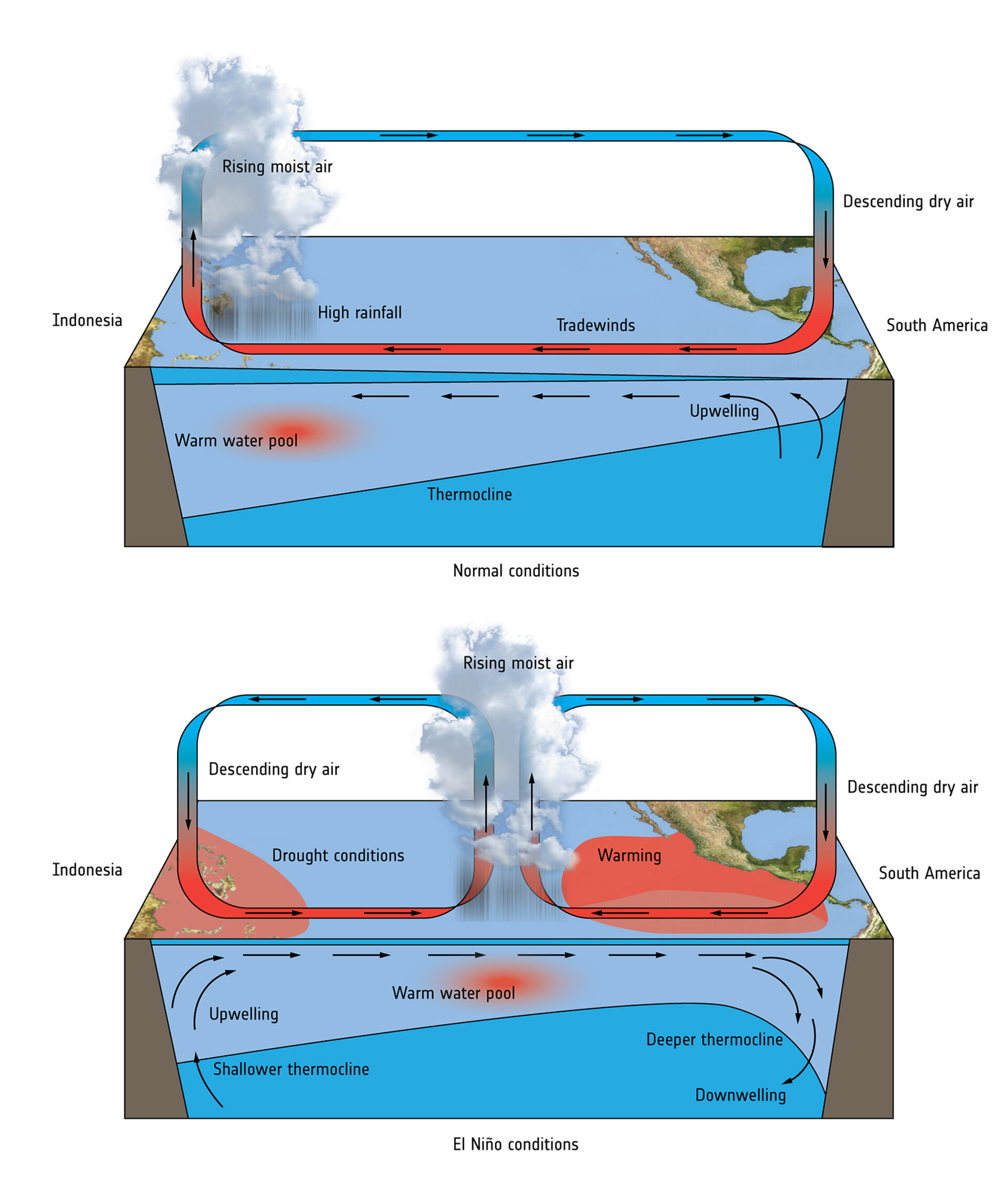
- Along the western coast of South America, the ITCZ is usually above the equator throughout the year, this results in strong trade winds.
- The offshore trade winds push the water, away from the coast, causing cold water upwelling, along the eastern pacific in addition to existing cold ocean currents.
- This reduces the water temperature and the air above this cold water is dry and stabilized, and Convection is suppressed.
- Water flows westward as southeast trade winds blow toward the western pacific region.
- This water gets heated up and rises through convection causing cloud formation and precipitation along the western pacific.
- The rising air flows eastward, in the upper troposphere, and descends along the eastern pacific completing the cell.
- This results in high pressure and low temperature, in the eastern pacific ocean.
- And high temperature and low pressure in the western pacific region.
- This results in the convective cell, known as walker circulation.
- In normal conditions, the eastern pacific coast experiences, drought, and the western pacific experiences good rainfall.

El Nino (6:07 PM)
- Once in 3-7 years in October-November, the ITCZ moves too much south to the equator.
- This results in the weakening of trade winds and disruption of upwelling.
- The warm tropical surface waters, earlier flowing towards the west, flow back eastwards, causing a further reduction in the upwelling.
- This results in warm surface water on the coast, of central and South America, which is called as El-Nino.
- The appearance of El Nino causes the air pressure to drop over the eastern pacific coast and rise over the western pacific.
- This see-saw variation, of air pressure, is called El Nino southern oscillation (ENSO)
- El Nino causes heavy precipitation along the eastern pacific and drought conditions along the western pacific.
- After one or two years the enhanced Hadley circulation strengthens the trade winds and increases the upwelling, bringing back the normal condition
- Impacts of El NINO
- (a) The disturbance of the walker circulation causes the disturbance in global weather patterns and the convective cycles are also disturbed in other oceans.
- (b) It causes drought and dry conditions in India and Australia.
- (c) It negatively impacts Indian Monsoon, causing delays in monsoon, a decrease in precipitation as well as an increase in the number of breaks in monsoon.
- (d) It causes heavy precipitation along the coastal deserts of Peru and Chile.
- (e) The dry condition in India and Australia triggers forest fires and bushfires.
- (f) the warm water along the eastern pacific along Peru and chile coast inhibits the growth of plankton and algae and suppresses upwelling devastating the marine ecosystem, and killing fish on large scale.
- (g) It results in a catastrophic impact on the fishing and fertilizer industry.
- (h) the decomposition of fish releases hydrogen sulfide, causing dark waters and making it toxic.
- (i) El Nino years cause mass coral bleaching due to disturbance of the stable conditions and higher temperature.
- (j) It results in severe dust storms in India and Australia.
- (k) During El NINO, high-pressure conditions in the Caribbean Sea, Western Pacific, and Bay of Bengal suppress the cyclone formation.
- The strongest recorded El Nino was in 1982-83, 1997-98, and 2014-16, 2018-19.
La Nina (6:27 PM)
- El Nino is usually followed by La Nina.
- It is the intensified high pressure, and cold temperature along the eastern pacific and lower low pressure and higher high temperature along the western pacific.
- This causes very heavy precipitation, in India and Australia, resulting in floods.
- The La Nina Years, 2020-21, 21-22, 22-23. This is called Triple Dip. (La Nina consecutively in three years)
El Nino Modoki (7:21 PM)
- Modoki means similar but different.
- While El Nino is characterized by strong warming in the eastern pacific ocean, El Nino Modoki results in warming in the central pacific with cooling in the eastern and western pacific oceans.
- It creates a two-cell Walker circulation over the tropical pacific region, with precipitation in the central part and dry conditions in the eastern and western parts.
- While El Nino results in diminished hurricanes in the Caribbean sea, El Nino Modoki results in increased hurricanes.
- During this time, the number of cyclones is more in the Arabian sea, than in the Bay of Bengal

Madden Julian oscillation (MJO) (7:39 PM)
- Unlike ENSO which is stationary, MJO is an eastward moving disturbance of clouds, rainfall, winds, and pressure that traverses the planet in the tropics and returns to its initial starting point in 30-60 days on average.
- MJO has two parts, the convective part with enhanced rainfall and the subsiding part with suppressed rainfall.
- MJO can influence the timing and strength of monsoons, as well as tropical cyclones.
- MJO can increase or decrease the impact of El Nino on India.


Indian Ocean Dipole (IOD) (7:44 PM)
- The difference in sea-surface temperature between the Western Arabian sea and the eastern Indian Ocean, near Indonesia and Australia is called as Indian Ocean Dipole.
- Similar to MJO, it is a coupled ocean and atmospheric phenomenon.
- Positive IOD
- Warm sea surface in the western part compared to the east.
- Less rainfall in Indonesia and Australia.
- It is good for Indian Monsoon.
- Reduces the impact of El Nino on India.
- Arabian sea experiences a higher number of cyclones than the Bay of Bengal.
- Negative IOD
- Warm sea surface along the eastern part than the western part.
- More rainfall in Indonesia and Australia.
- Negatively impacts the Indian Monsoon.
- Increases the effect of El Nino on India.
The topics for the Next Class: Heat Domes, Biogeography